


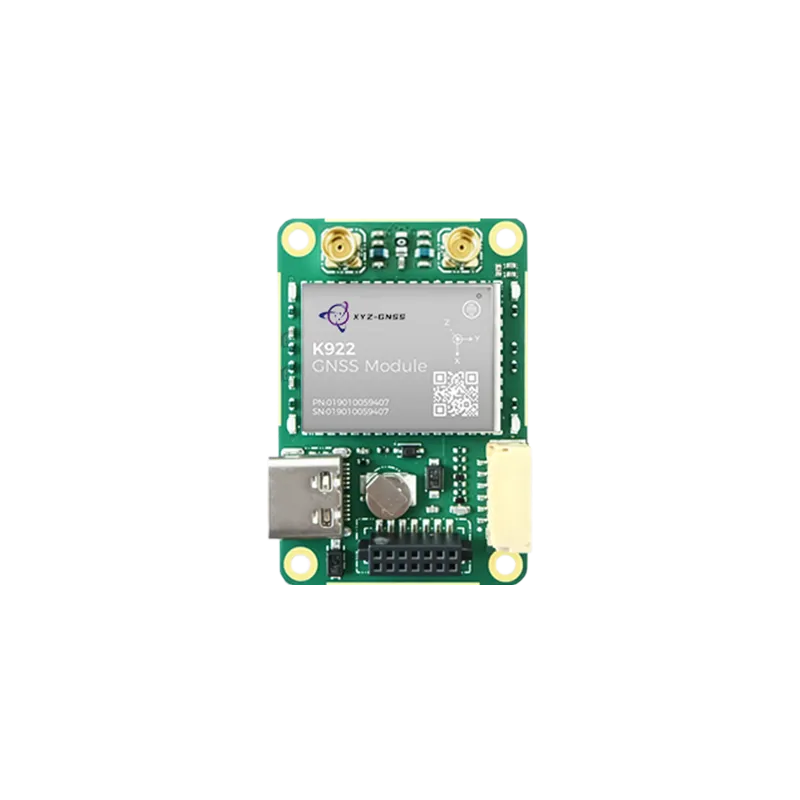
The evolution of robotics and unmanned platforms has created an unprecedented demand for high-accuracy positioning. At the heart of this revolution is the RTK GNSS module for autonomous systems, a critical component that bridges the gap between general navigation and centimeter-level precision. In the past, autonomous platforms relied on standard Global Navigation Satellite System (GNSS) signals, which often resulted in errors of several meters. However, modern industrial applications, ranging from automated container terminals to precision drone delivery, require accuracy that only Real-Time Kinematic (RTK) technology can provide. By utilizing carrier-phase measurements and differential corrections, these modules allow autonomous platforms to determine their position with incredible exactness, ensuring safety and operational efficiency in complex environments.
Understanding the role of RTK GNSS module for autonomous systems
An RTK GNSS module for autonomous systems works by comparing signals from a satellite constellation with data provided by a fixed base station or a CORS network. This process eliminates common errors such as atmospheric delays, satellite clock bias, and orbital inaccuracies. For an autonomous vehicle or robot, this means the difference between staying on a narrow path or drifting into an obstacle. The integration of such modules is not merely an upgrade; it is a fundamental requirement for any system intended to operate without human intervention in high-stakes environments. These modules support multiple constellations, including GPS, BDS (Beidou), GLONASS, and Galileo, ensuring that even if one satellite network is obstructed, the system maintains a high fix rate and reliable data output.
In the context of modern engineering, the RTK GNSS module for autonomous systems serves as the primary sensory input for path planning and localization. Unlike cameras or LiDAR, which can be affected by lighting or featureless landscapes, GNSS provides a global reference frame that remains consistent over large distances. When combined with Inertial Measurement Units (IMU), these modules form a robust navigation engine capable of handling high-dynamic maneuvers. This fusion of technologies ensures that the autonomous system remains "aware" of its location even during temporary signal loss, which is vital for safety-critical applications like urban air mobility and autonomous trucking.
Technical foundations of high precision positioning
To truly appreciate the value of an RTK GNSS module for autonomous systems, one must understand the underlying technology of multi-frequency tracking. Modern modules typically operate across L1, L2, and L5 frequencies. By receiving signals on multiple bands, the module can significantly reduce the time required to achieve a "fixed" solution—the state where centimeter-level accuracy is achieved. This is particularly important for autonomous systems that need to initialize quickly or recover from signal obstructions in "urban canyons" or under dense foliage. High-end modules also incorporate advanced algorithms to mitigate multipath interference, which occurs when signals reflect off buildings or the ground before reaching the antenna.
Furthermore, the data update rate is a critical metric for autonomous applications. A high-performance RTK GNSS module for autonomous systems can provide position updates at frequencies of 10Hz, 20Hz, or even higher. For a drone flying at 15 meters per second, a low update rate could mean the system only knows its position every few meters, which is insufficient for precision landing or obstacle avoidance. By providing high-frequency updates, the module allows the flight controller or vehicle computer to make real-time adjustments to its trajectory, ensuring smooth and predictable motion control. This level of responsiveness is what differentiates a toy-grade system from a professional-grade industrial solution.
Integration challenges and best practices
Integrating an RTK GNSS module for autonomous systems requires careful consideration of both hardware and software. One of the most significant challenges is Electromagnetic Interference (EMI). Autonomous platforms are often packed with high-power motors, radio transmitters, and microprocessors, all of which generate noise that can drown out weak satellite signals. Designers must use shielded cables and place the GNSS antenna far from interference sources to maintain a high Signal-to-Noise Ratio (SNR). Additionally, the choice of antenna is paramount; a high-gain, multi-frequency antenna is necessary to capture the delicate carrier-phase data required for RTK calculations.
On the software side, the autonomous system must be capable of processing the NMEA or proprietary binary data streams coming from the module. Most modern RTK GNSS modules for autonomous systems use standardized protocols like RTCM (Radio Technical Commission for Maritime Services) for receiving correction data. Engineers must set up a reliable communication link—via 4G/5G, radio telemetry, or Wi-Fi—to deliver these corrections to the rover module in real-time. Failure to maintain a low-latency correction link will result in the system falling back to "Float" or "DGPS" mode, where accuracy degrades from centimeters to decimeters or meters, potentially compromising the mission.
Industry specific implementations and benefits
In the world of precision agriculture, an RTK GNSS module for autonomous systems allows tractors and harvesters to follow paths with an accuracy of 2.5 centimeters. This prevents overlapping rows, reduces fuel consumption, and optimizes the application of seeds and fertilizers. Similarly, in the field of robotic lawn mowers, RTK technology eliminates the need for buried boundary wires. The mower can be programmed with digital boundaries, and the high-precision module ensures it stays within the designated area while following an efficient striping pattern. These improvements lead to direct cost savings and increased operational lifespan for the hardware.
For Unmanned Aerial Vehicles (UAVs), the benefits are even more pronounced. In surveying and mapping, a drone equipped with an RTK GNSS module for autonomous systems can geotag photos with such precision that the need for Ground Control Points (GCPs) is significantly reduced or eliminated. This saves hours of manual labor on the ground and allows for the creation of highly accurate 3D models and orthophotos. In infrastructure inspection, RTK enables drones to fly safely close to power lines or bridges, maintaining a consistent distance that would be impossible with standard GPS. This precision is the key to scaling autonomous operations from experimental pilots to full-scale commercial services.
The Yonghao advantage in precision navigation
As a leader in high-precision positioning, Yonghao provides a comprehensive suite of hardware designed to meet the rigorous demands of modern industry. Our commitment to excellence is reflected in our diverse product lineup, which includes high-performance RTK GNSS module for autonomous systems solutions tailored for various applications. Whether you are building a compact consumer robot or a massive agricultural machine, Yonghao offers the technical expertise and hardware reliability required to succeed.
Our flagship products, such as the UM982 and the ZED-F9P compatible boards, provide multi-constellation, multi-frequency support with integrated heading capabilities. For developers seeking the ultimate in reliability and small form factor, the Mini-mosaic-G5 offers an industrial-grade solution that excels in high-vibration and interference-prone environments. At Yonghao, we don't just sell modules; we provide the foundation for the future of autonomous mobility. Our products are rigorously tested to ensure they maintain a stable RTK fix even in challenging conditions, giving our clients the confidence to deploy their systems worldwide.
Conclusion
The transition toward fully autonomous operations is accelerating, and the RTK GNSS module for autonomous systems is the catalyst for this change. By providing the precision necessary for complex tasks, these modules are enabling industries to reach new levels of productivity and safety. From the farm to the construction site and the sky above, high-precision positioning is transforming how we interact with the world. As technology continues to advance, we can expect even more integrated, compact, and powerful GNSS solutions to emerge, further blurring the line between human-operated and truly autonomous machines.
Frequently Asked Questions
Q1: How does an RTK GNSS module for autonomous systems differ from a standard GPS module?
A standard GPS module provides accuracy within 2 to 5 meters by measuring signal travel time. In contrast, an RTK GNSS module for autonomous systems uses the carrier phase of the satellite signal and real-time corrections from a base station to achieve centimeter-level accuracy, which is essential for precise navigation and safety.
Q2: What is the maximum range for an RTK GNSS module for autonomous systems from its base station?
Typically, an RTK GNSS module for autonomous systems can maintain centimeter-level accuracy within 20 to 30 kilometers of a base station. For larger areas, users often utilize NTRIP/CORS networks which provide corrections via the internet, allowing for extended range across entire regions or countries.
Q3: Can an RTK GNSS module for autonomous systems work in areas with no cellular signal?
Yes, if cellular data is unavailable for NTRIP corrections, an RTK GNSS module for autonomous systems can receive corrections via LoRa or UHF radio from a local physical base station. This makes it ideal for remote agricultural or mining sites where internet connectivity is limited.
Q4: Does Yonghao provide support for integrating an RTK GNSS module for autonomous systems?
Absolutely. Yonghao offers comprehensive technical support and documentation for all our modules. We help engineers optimize antenna placement, configure communication protocols, and troubleshoot signal interference issues to ensure the RTK GNSS module for autonomous systems performs at its peak in your specific application.
Q5: Is an RTK GNSS module for autonomous systems affected by bad weather?
While heavy rain or thick clouds can slightly attenuate signals, a high-quality RTK GNSS module for autonomous systems is designed to be highly resilient. By using multiple frequencies (L1/L2/L5) and multiple constellations, the module can mitigate most atmospheric disturbances and maintain a reliable position fix during adverse weather conditions.
Ready to elevate your autonomous platform?
Contact our team today to find the perfect high-precision positioning solution for your project.
Contact Yonghao Experts