


As global infrastructure continues to age and expand, the need for millimetric and centimetric precision in structural health monitoring has become paramount. Modern engineering relies on advanced satellite technology to detect the slightest shifts in stability.
The critical role of high-precision monitoring in modern engineering
Maintaining the structural integrity of bridges, dams, high-rise buildings, and open-pit mines requires constant vigilance. Traditional manual surveying methods, while accurate, are often labor-intensive, time-consuming, and unable to provide the continuous, real-time data necessary for early warning systems. This is where the integration of an RTK GNSS module for deformation monitoring becomes an industry-changing solution. By leveraging Real-Time Kinematic (RTK) technology, engineers can achieve high-frequency positioning updates that identify surface displacements as they happen.
The shift toward automated systems has been driven by the increasing complexity of infrastructure projects located in geologically unstable regions. An automated monitoring system ensures that even the smallest movements, which might precede a catastrophic failure, are captured and analyzed immediately. This proactive approach not only saves lives but also significantly reduces long-term maintenance costs by allowing for targeted repairs rather than emergency reconstructions.
Furthermore, the evolution of Global Navigation Satellite System (GNSS) constellations—including GPS, GLONASS, Galileo, and BDS—has provided the foundation for unprecedented reliability. When a specialized module is deployed, it utilizes multi-frequency signals to mitigate errors caused by atmospheric conditions or signal obstructions. This creates a robust framework for permanent monitoring installations that operate 24/7 in harsh outdoor environments.
The technical mechanics of RTK GNSS module for deformation monitoring
At its core, the technology relies on the carrier phase of the satellite signal rather than just the code information. This allows the system to resolve the integer ambiguity and determine the distance between the satellite and the receiver with extreme precision. When using an RTK GNSS module for deformation monitoring, the setup typically involves a fixed base station and one or more rover modules placed on the structure being monitored. The base station transmits correction data to the rovers, which then calculate their relative positions in real-time.
One of the most significant technical hurdles in deformation monitoring is the multipath effect, where satellite signals reflect off nearby surfaces before reaching the antenna. High-quality modules incorporate advanced algorithms and filtering techniques to distinguish between direct and reflected signals. This ensures that the data used for structural analysis is clean and representative of actual physical movement rather than environmental noise.
Additionally, the integration of multi-constellation support is vital. By accessing signals from BDS, GPS, and Galileo simultaneously, the module increases the number of available satellites. This is particularly important in deep valleys or urban canyons where a significant portion of the sky may be blocked. The resulting high "satellite availability" translates directly into faster time-to-first-fix (TTFF) and more stable positioning results, which are non-negotiable for safety-critical monitoring tasks.
Essential features of a reliable RTK GNSS module for deformation monitoring
Selecting the right hardware is the first step toward a successful monitoring project. A reliable RTK GNSS module for deformation monitoring must offer low power consumption, a compact form factor, and high thermal stability. Since these modules are often installed in remote locations powered by solar panels and batteries, power efficiency ensures the system remains operational during periods of low sunlight. Compact designs allow for easier integration into weatherproof enclosures or specialized monitoring hardware.
Another critical feature is the raw data output capability. For geodetic applications, engineers often require access to raw carrier phase and Doppler observations for post-processing tasks. While real-time data provides immediate alerts, post-processed kinematic (PPK) analysis can further refine the accuracy to sub-centimeter levels by using high-precision ephemeris data. A module that supports both RTK and raw data output offers the highest level of flexibility for diverse engineering requirements.
Interface compatibility also plays a major role. Most modern industrial systems utilize UART, USB, or CAN bus interfaces for data communication. The ability to seamlessly connect the GNSS module to a cellular gateway or a local industrial PC is essential for transmitting data to the cloud. With the rise of IoT, the ability for a module to output standard NMEA messages alongside high-precision proprietary formats makes it compatible with a wide range of software platforms used in the structural health monitoring industry.
Why multi-frequency support is vital for engineering projects
Single-frequency receivers are often susceptible to ionospheric delays, which can introduce errors of several meters if not corrected. In contrast, multi-frequency modules (supporting L1, L2, and L5 bands) can cancel out these atmospheric errors by comparing the signals from different frequencies. For infrastructure projects, where even a 5-centimeter error could be misinterpreted as a structural crack, the precision afforded by multi-frequency technology is indispensable.
Moreover, multi-frequency support significantly enhances the reliability of the RTK fix. In challenging environments, the module can regain its centimeter-level accuracy much faster after a signal dropout. This "high availability" of the RTK solution ensures that there are no gaps in the monitoring timeline. For projects involving high-speed high-speed rail tracks or seismic-prone bridges, continuous data is the only way to ensure the safety of the public and the longevity of the assets.
Advanced modules also feature anti-interference and anti-jamming capabilities. With the proliferation of wireless signals in industrial areas, the risk of GNSS interference is growing. Professional-grade modules utilize digital filtering and specialized antenna designs to isolate the satellite signals from surrounding electronic noise. This ensures that the monitoring system remains resilient even in complex electromagnetic environments, providing peace of mind to project managers and stakeholders.
Professional GNSS solutions from Yonghao
Yonghao is a leading innovator in the field of high-precision positioning technology, providing specialized hardware for the most demanding industrial applications. We understand that infrastructure safety depends on the accuracy of the data collected, which is why our products are designed to exceed industry standards. Our range of RTK GNSS module for deformation monitoring options provides the stability and precision required for long-term deployments.
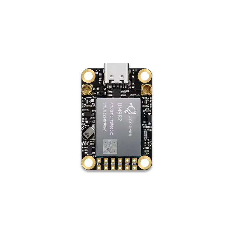
One of our flagship offerings is the UM980, a full-band centimetric-level positioning board that serves as an excellent replacement for traditional high-cost units. It is specifically optimized for surveying, mapping, and deformation monitoring. For those requiring integrated all-in-one solutions, the Yhrtk-980 offers multi-constellation and multi-frequency support, ensuring robust performance in any geographical location.
Beyond hardware, Yonghao provides comprehensive technical support and customization services to ensure our modules integrate perfectly with your existing monitoring systems. Whether you are building a new bridge monitoring network or upgrading a landslide early warning system, our team is dedicated to providing the reliable technology you need to succeed. Our commitment to quality is reflected in every module we produce, helping engineers worldwide build a safer future.
Frequently asked questions
Q1: How accurate is an RTK GNSS module for deformation monitoring in real-world conditions?
In optimal conditions with a clear view of the sky, a high-quality RTK GNSS module can achieve horizontal accuracy of approximately 8mm to 10mm and vertical accuracy of 15mm to 20mm. At Yonghao, our modules like the UM980 are tested extensively to ensure they maintain this level of precision even in industrial environments where signal reflections might occur.
Q2: What are the power requirements for a permanent RTK GNSS module for deformation monitoring setup?
Most of our professional modules are designed for low power consumption, typically drawing less than 1.0W to 1.5W during full operation. This makes them ideal for solar-powered remote stations. By integrating our energy-efficient boards, engineers can reduce the size and cost of the battery systems needed for continuous operation.
Q3: Can the RTK GNSS module for deformation monitoring work during extreme weather conditions?
Yes, our industrial-grade modules are rated for wide temperature ranges, often from -40 degrees Celsius to +85 degrees Celsius. While heavy rain or snow can slightly attenuate satellite signals, the use of multi-frequency technology allows the system to maintain a stable lock and continue providing reliable deformation data throughout the storm.
Q4: Does Yonghao offer support for integrating the RTK GNSS module for deformation monitoring into custom software?
Absolutely. We provide detailed documentation, SDKs, and NMEA protocol support to help developers integrate our hardware into their proprietary structural health monitoring (SHM) platforms. Our technical team is available to assist with configuration and troubleshooting during the initial development phase.
Q5: Why should I choose a multi-constellation RTK GNSS module for deformation monitoring over a GPS-only model?
A multi-constellation module can track signals from GPS, BDS, GLONASS, and Galileo simultaneously. This significantly increases the number of satellites in view, which is critical for maintaining an RTK fix in obstructed environments. It ensures higher reliability and faster convergence times, which are essential for timely deformation alerts.
Build more resilient infrastructure with Yonghao
The safety of our bridges, dams, and buildings depends on the quality of the sensors we use to monitor them. By choosing a professional-grade RTK GNSS module, you are investing in the long-term reliability of your infrastructure projects.