


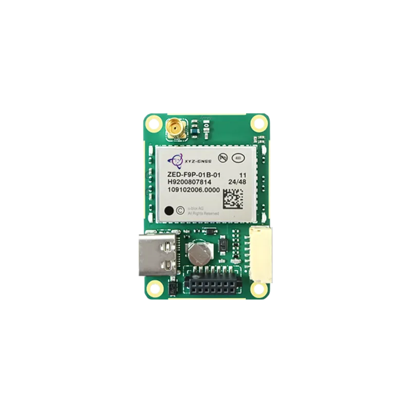
Exploring the transformative impact of Real-Time Kinematic technology on modern unmanned aerial systems and industrial applications.
The evolution of precision in drone navigation
In the rapidly advancing world of unmanned aerial vehicles (UAV), the demand for high-precision positioning has never been more critical. Traditional GPS systems provide meter-level accuracy, which is often sufficient for recreational flying but falls short in industrial sectors such as land surveying, precision agriculture, and infrastructure inspection. This is where the RTK GNSS module for drones becomes an indispensable asset. By utilizing Real-Time Kinematic technology, these modules provide centimeter-level accuracy, allowing drones to maintain stable hover positions and execute flight paths with surgical precision.
The core mechanism involves a carrier-based differential GNSS technique that provides real-time corrections. For professionals, this means eliminating the need for extensive ground control points (GCPs) in photogrammetry. When an RTK GNSS module for drones is integrated into the flight stack, the metadata of every captured image contains precise coordinates, drastically reducing post-processing time and increasing the reliability of the final 3D models or orthomosaic maps.
As industrial drones transition from simple observation tools to complex data acquisition platforms, the reliability of the GNSS receiver determines the project's success. Whether it is navigating through tight corridors in urban environments or maintaining a steady heading in high-wind conditions, the enhanced satellite signal processing of modern modules ensures that the UAV remains on its intended trajectory without drifting.
Technical architecture of an RTK GNSS module for drones
Understanding the technical nuances of an RTK GNSS module for drones requires a deep dive into how it handles multi-constellation and multi-frequency signals. Modern modules do not rely solely on GPS; they integrate signals from BDS, GLONASS, Galileo, and QZSS. This multi-system approach ensures that even if one constellation is partially obstructed by terrain or buildings, the receiver can still calculate a precise position using other available satellites.
Frequency diversity is another critical factor. Dual-frequency or triple-frequency modules (such as those supporting L1, L2, and L5) can effectively mitigate ionospheric delays and reduce the time required to reach a fixed solution. When a drone takes off, the RTK system must achieve a "fix" status, where the carrier phase ambiguities are resolved. With high-end modules, this initialization process happens within seconds, ensuring the drone is ready for operation without unnecessary delays on the ground.
Furthermore, the integration of heading and positioning capabilities within a single module has revolutionized drone design. By using dual-antenna setups connected to a single high-performance GNSS board, a drone can determine its heading even when stationary. This is particularly vital for industrial UAVs that carry heavy payloads or sensors that require a specific orientation, such as LiDAR or thermal cameras. The stability provided by an RTK GNSS module for drones allows for consistent data collection regardless of magnetic interference.
Industrial benefits of high-precision UAV integration
The practical benefits of deploying an RTK GNSS module for drones span across multiple high-stakes industries. In precision agriculture, drones equipped with RTK can follow automated flight paths with 1-2 centimeter accuracy, ensuring that crop spraying or multispectral analysis is applied exactly where it is needed. This level of precision prevents overlaps or gaps in coverage, leading to significant cost savings in chemicals and improved crop yields.
In the construction and mining sectors, RTK-enabled drones are used for volumetric calculations and site monitoring. By capturing high-resolution data with accurate georeferencing, project managers can track the progress of a site day-by-day. The ability to overlay new scans onto CAD designs with centimeter accuracy ensures that any deviations from the plan are detected immediately, preventing expensive errors and ensuring safety compliance throughout the project lifecycle.
Infrastructure inspection, particularly for power lines and wind turbines, also relies heavily on these modules. A drone must fly in close proximity to high-voltage lines or massive rotating blades. Magnetic interference from power lines can often confuse traditional compasses. However, an RTK GNSS module for drones provides a robust alternative for orientation and positioning, allowing the flight controller to maintain safety margins and execute precise maneuvers without the risk of collision or signal loss.
Strategic integration and anti-jamming considerations
Integrating an RTK GNSS module for drones involves more than just hardware mounting; it requires careful consideration of the electromagnetic environment. Drones are compact machines where the GNSS antenna is often located near high-frequency components like ESCs (Electronic Speed Controllers) and telemetry radios. Professional integration strategies involve using shielded cables and optimized ground planes to ensure the GNSS signals remain clean and unobstructed.
Anti-jamming technology has become a cornerstone of UAV security. In sensitive areas or complex electronic environments, GNSS signals can be subject to interference or spoofing. Modern high-precision modules now incorporate advanced digital signal processing (DSP) to identify and filter out rogue signals. This ensures that the drone maintains its "fix" even in challenging conditions, providing a layer of operational security that is essential for autonomous delivery drones and defense-related applications.
Moreover, the move towards miniaturization has led to the development of all-in-one modules that combine the GNSS receiver and the antenna. These compact solutions reduce the overall weight of the UAV, extending flight time without sacrificing positioning performance. For developers, choosing a module with a standardized interface (such as UART or CAN bus) ensures compatibility with popular flight controllers like Pixhawk or customized proprietary systems, streamlining the research and development cycle.
Why choose Yonghao for your drone positioning needs
Yonghao stands at the forefront of satellite navigation technology, specializing in the development of high-performance components for the UAV industry. Our expertise in RTK GNSS module for drones manufacturing allows us to provide solutions that meet the rigorous demands of professional pilots and system integrators worldwide. We understand that in the drone industry, every gram of weight and every milliwatt of power counts, which is why our products are optimized for efficiency and reliability.
Our product lineup includes the latest in multi-frequency technology. For instance, the RTK GNSS module UM982 offers exceptional heading and positioning performance, making it ideal for large-scale industrial UAVs. For those seeking a versatile and widely compatible option, our RTK GNSS module ZED-F9P provides a cost-effective yet powerful solution for robotic systems and autonomous vehicles.
Beyond standard modules, Yonghao offers comprehensive RTK GNSS module solutions tailored for specific applications such as precision agriculture and geodetic surveying. Our commitment to innovation is reflected in our advanced anti-jamming systems, ensuring your flight operations remain safe from external interference. Whether you are building a custom drone or upgrading an existing fleet, our technical support team is ready to assist with integration and optimization.
Our core advantages include:
Centimeter-level accuracy across all major global satellite constellations (GPS, BDS, GLONASS, Galileo).
Robust anti-interference capabilities for stable flight in complex electromagnetic environments.
Lightweight and compact designs that maximize UAV flight duration and payload capacity.
Customization services to meet unique industrial or research requirements.
The future of autonomous drone flight
As the drone industry moves towards full autonomy, the role of high-precision positioning will only grow in importance. The implementation of an RTK GNSS module for drones is the foundation upon which safe, efficient, and scalable UAV operations are built. By investing in quality GNSS hardware, companies can unlock the full potential of aerial data, transforming how we interact with and monitor the physical world. Yonghao remains dedicated to pushing the boundaries of what is possible in satellite navigation, providing the tools necessary for the next generation of aerial innovation.
Frequently asked questions
Q1: How does an RTK GNSS module for drones improve mapping accuracy?
An RTK GNSS module for drones provides real-time corrections to the satellite data, reducing positioning errors from several meters down to just 1-2 centimeters. This means that each photograph taken during a mapping mission is tagged with highly accurate spatial data, ensuring the final map is geographically precise without requiring numerous ground control points.
Q2: Can I use an RTK GNSS module for drones in urban areas with high-rise buildings?
Yes, modern RTK GNSS module for drones solutions from Yonghao use multi-constellation (GPS, BDS, etc.) and multi-frequency signals to maintain a stable fix even in "urban canyons." While signal obstructions are always a challenge, the ability to track more satellites significantly improves reliability in difficult environments.
Q3: What is the difference between PPK and using an RTK GNSS module for drones?
RTK (Real-Time Kinematic) processes corrections instantly during the flight, which is essential for precision navigation and hovering. PPK (Post-Processed Kinematic) processes the data after the flight. While both offer similar accuracy for mapping, an RTK GNSS module for drones is superior for applications requiring real-time flight control and obstacle avoidance.
Q4: Does Yonghao provide technical support for integrating an RTK GNSS module for drones?
Absolutely. Yonghao offers comprehensive technical support for our customers. We assist with hardware selection, antenna placement, and software configuration to ensure your RTK GNSS module for drones performs optimally with your specific flight controller and mission requirements.
Q5: Is it difficult to install an RTK GNSS module for drones on a custom UAV?
The difficulty depends on the flight controller used, but most modern systems support standard communication protocols like UART or CAN. Yonghao designs every RTK GNSS module for drones with integration in mind, providing clear documentation and standardized interfaces to make the installation process as straightforward as possible for developers.