


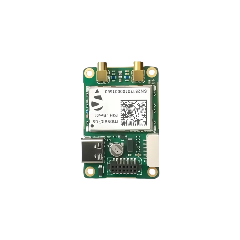
A comprehensive guide to integrating high-precision RTK technology for autonomous systems and industrial robotics.
The evolution of precision in autonomous systems
In the rapidly expanding world of autonomous systems, the demand for precise positioning has never been higher. Traditional GPS solutions, which typically offer an accuracy of 2 to 5 meters, are no longer sufficient for tasks that require surgical precision, such as autonomous row-cropping, industrial warehouse delivery, or infrastructure inspection. This is where the RTK GNSS module for robotics navigation becomes a critical component. By utilizing real-time kinematic (RTK) technology, robotics developers can bridge the gap between "roughly where the robot is" and "exactly where the robot needs to be."
RTK works by measuring the phase of the signal carrier wave, rather than just the information content of the signal. It relies on a fixed base station and a mobile rover to provide corrections that eliminate atmospheric errors and satellite clock offsets. For any modern engineer, understanding the nuances of how an RTK GNSS module for robotics navigation interacts with the environment and the robot onboard computer is essential. This guide will delve into the technical intricacies, hardware selection, and practical applications of these high-precision modules, focusing on how they empower the next generation of smart machines.
Understanding the mechanics of the RTK GNSS module for robotics navigation
The fundamental principle behind an RTK GNSS module for robotics navigation involves the use of two receivers. One is stationary, known as the base station, and the other is moving, known as the rover. The base station broadcasts its known position along with the raw satellite observations to the rover in real-time, usually via a radio link or internet connection (NTRIP). The rover then processes this data to calculate its relative position to the base station with an accuracy of approximately 1 centimeter plus 1 part per million of the distance from the base.
Modern modules have evolved to support multiple constellations, including GPS, GLONASS, Galileo, and Beidou (BDS). Multi-band support (L1, L2, and L5) is particularly important because it allows the module to resolve the carrier-phase ambiguity much faster, even in challenging environments. When a robot moves between tall buildings or under tree canopies, having access to multiple frequencies ensures that the navigation system remains robust. Furthermore, the integration of inertial measurement units (IMU) within the GNSS module has led to the rise of GNSS+INS fusion, which maintains positioning during short signal outages.
Key components for building a high-precision navigation stack
Selecting the right hardware is the first step toward achieving reliable autonomy. A standard setup requires more than just the chip itself. It involves a high-quality antenna, a robust communication link, and a processing unit capable of handling high-update rates. For instance, many agricultural and survey-grade robots utilize modules like the ZED-F9P or the UM982. These modules are preferred because they offer dual-antenna support, allowing the robot to determine its heading (yaw) even when stationary, which is a massive advantage over single-antenna systems that require movement to calculate direction.
The antenna choice is equally critical. A high-gain, multi-frequency antenna with excellent multipath rejection capabilities ensures that the signal remains clean. In robotics, where electromagnetic interference (EMI) from motors and electronic speed controllers (ESC) is common, shielding and proper placement of the RTK GNSS module for robotics navigation components are vital. Developers must also consider the interface requirements, such as UART, USB, or CAN bus (often using the UAVCAN protocol in the drone industry), to ensure seamless integration with flight controllers or single-board computers like the Raspberry Pi or NVIDIA Jetson.
Primary applications of precision GNSS in modern industry
The utility of an RTK GNSS module for robotics navigation spans across numerous sectors. In precision agriculture, autonomous tractors and weeding robots use RTK to follow pre-programmed paths with centimeter accuracy, ensuring that crops are not damaged and resources like water and fertilizer are applied efficiently. This level of precision is the cornerstone of the "digital farm" concept, where every square inch of the field is mapped and managed. Without RTK, autonomous farming would be limited to very basic tasks with high margins of error.
Beyond the fields, delivery robots and autonomous lawnmowers are utilizing these modules to navigate complex urban and suburban environments. A robotic lawnmower equipped with an RTK GNSS module for robotics navigation can eliminate the need for underground perimeter wires, allowing for easier setup and more flexible mowing patterns. Similarly, in the inspection industry, UAVs (unmanned aerial vehicles) use RTK to maintain stable hovers near power lines or bridges, capturing high-resolution data without the risk of drifting into obstacles. The reliability provided by RTK fundamentally changes the safety profile of these operations.
Overcoming signal interference and environmental obstacles
Despite its power, RTK navigation faces challenges, particularly in "urban canyons" or dense forests where satellite signals are reflected or blocked. Multipath interference—where a signal bounces off a building before reaching the antenna—can introduce significant errors. To mitigate this, advanced modules employ sophisticated algorithms to filter out reflected signals. Furthermore, the use of anti-jamming technology has become paramount. As robotic systems become more critical to infrastructure, protecting the GNSS receiver from intentional or unintentional interference is a top priority for security-conscious developers.
Another challenge is the maintenance of the correction link. If the robot loses its connection to the base station or the NTRIP caster, the accuracy will gradually degrade from RTK fixed to RTK float, and eventually to standard autonomous mode. Modern solutions address this by incorporating long-range (LORA) radios for local base stations or using satellite-delivered corrections (PPP-RTK) which do not require a local internet connection. This ensures that the RTK GNSS module for robotics navigation remains operational even in the most remote locations on earth.
Why Yonghao is your strategic partner in high-precision GNSS
At Yonghao, we specialize in providing industry-leading positioning solutions tailored for the most demanding robotic applications. We understand that every robot is unique, which is why we offer a comprehensive range of products designed to integrate seamlessly into your navigation stack. Our flagship RTK GNSS module for robotics navigation series provides the stability and accuracy required for mission-critical tasks.
Our product lineup includes the highly acclaimed UM982, which offers dual-frequency multi-constellation positioning and heading, making it perfect for UAVs and ground vehicles. For those looking for a versatile and widely compatible solution, our ZED-F9P based modules are industry favorites. Beyond modules, we also provide professional-grade RTK GNSS antenna solutions and advanced anti-jamming devices to ensure your robot stays on track even in hostile signal environments. Yonghao is committed to driving innovation through engineering excellence and robust technical support.
Frequently asked questions about RTK GNSS
Q1: What are the main benefits of using an RTK GNSS module for robotics navigation in agriculture?
The primary benefit is centimeter-level repeatability. This allows agricultural robots to return to the exact same spot in a field multiple times throughout a season, which is essential for tasks like targeted spraying, mechanical weeding, and automated harvesting. Yonghao products are specifically tested to withstand the harsh vibrations and environmental conditions of the agricultural sector.
Q2: How does an RTK GNSS module for robotics navigation handle signal loss in urban areas?
When signals are obstructed, a high-quality module will enter a float state, attempting to maintain as much accuracy as possible. However, Yonghao recommends using modules integrated with IMU sensors (GNSS+INS) to provide dead-reckoning capabilities, ensuring that the robot can continue to navigate safely for short periods without a clear satellite view.
Q3: Can I integrate an RTK GNSS module for robotics navigation into existing UAV platforms?
Yes, our modules are designed for high compatibility. They support standard protocols like NMEA and UBX, and can be easily connected to common flight controllers such as Pixhawk or DJI. For specialized drone applications, our lightweight modules ensure that the payload capacity is not compromised while providing professional-grade accuracy.
Q4: What is the cost-effectiveness of an RTK GNSS module for robotics navigation for small-scale startups?
In the past, RTK technology was prohibitively expensive, but with the advent of modules like those offered by Yonghao, the cost has dropped significantly. Startups can now achieve industrial-grade positioning at a fraction of the cost, allowing them to focus their resources on software development and market expansion.
Q5: How does Yonghao support customers using an RTK GNSS module for robotics navigation?
We provide comprehensive technical support, from initial hardware selection to post-integration troubleshooting. Our team of experts is available to help you optimize antenna placement, configure correction links, and ensure that your RTK GNSS module for robotics navigation is performing at its peak potential for your specific use case.
Elevate your robotic precision today
Ready to transform your autonomous systems with centimeter-level accuracy? Contact the experts at Yonghao for customized solutions and high-performance hardware.