


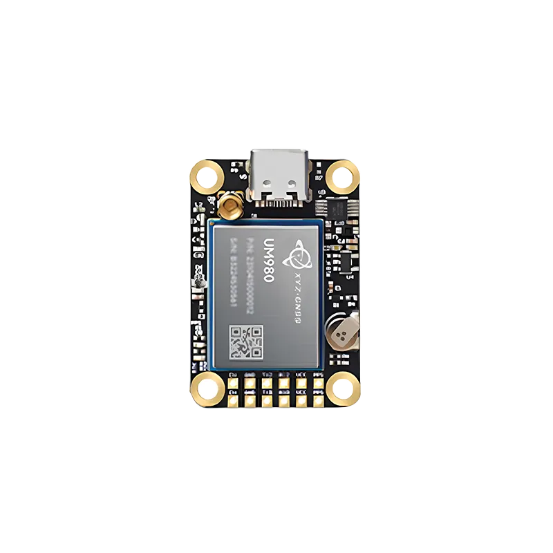
An authoritative guide to understanding, selecting, and implementing high-precision RTK technology for modern unmanned aerial systems.
The Evolution of High-Precision Navigation in Unmanned Systems
The landscape of aerial robotics has undergone a radical transformation over the past decade. Previously, standard global positioning systems provided accuracy within several meters, which was sufficient for general recreational flying but fell short for industrial applications. Today, the demand for centimeter-level precision has made the RTK GNSS module for UAV an essential component for professionals. Real-Time Kinematic (RTK) technology works by comparing the signals from a satellite constellation to a ground-based station, allowing the system to correct ionospheric delays and other signal errors in real-time. This level of accuracy is no longer a luxury; it is a requirement for tasks ranging from automated infrastructure inspection to high-density urban deliveries.
Implementing an RTK GNSS module for UAV allows operators to achieve a level of stability and repeatable accuracy that was previously impossible. By utilizing carrier-phase measurements rather than just code-phase data, these modules can resolve positions with an error margin of just 1-2 centimeters. This technological leap has empowered the drone industry to tackle complex challenges in environments where traditional GPS would fail due to signal multipath or atmospheric interference. As we delve deeper into the mechanics and applications of these systems, it becomes clear that the marriage of UAV platforms with RTK capabilities is the cornerstone of the next generation of autonomous flight.
Understanding the Architecture of an RTK GNSS Module for UAV
To fully appreciate the capabilities of a high-performance RTK GNSS module for UAV, one must understand its internal architecture. These modules are not simple receivers; they are sophisticated computers designed to process multi-frequency signals from multiple constellations including GPS, GLONASS, Galileo, and BeiDou. A typical professional-grade module features high-sensitivity RF front-ends and advanced digital signal processing (DSP) algorithms. The ability to track multiple frequencies (such as L1, L2, and L5) is crucial because it allows the module to quickly converge on a fixed solution, even in challenging environments with partial sky obstruction. This multi-band approach significantly reduces the time to first fix (TTFF) and enhances the robustness of the positioning data.
Furthermore, a modern RTK GNSS module for UAV often integrates inertial measurement units (IMUs) to provide fused navigation solutions. This technique, known as tightly coupled GNSS/INS integration, ensures that the UAV maintains its position even during brief satellite signal dropouts, such as when flying under bridges or near tall buildings. The module acts as the "brain" of the navigation system, constantly communicating with the flight controller via protocols like UART, USB, or CAN bus. For developers and engineers, selecting a module with a compact form factor and low power consumption is vital, as every gram and milliwatt impacts the flight duration and payload capacity of the drone. The shift toward miniaturized, all-in-one RTK boards has democratized access to precision technology for small-scale UAV manufacturers.
Strategic Integration Tips for RTK GNSS Module for UAV
Successfully integrating an RTK GNSS module for UAV requires more than just plug-and-play connectivity; it demands a strategic approach to hardware placement and electronic shielding. One of the most common issues in UAV design is electromagnetic interference (EMI) from high-power components like motors, electronic speed controllers (ESCs), and wireless video transmitters. To maximize the performance of your RTK module, it should be mounted as far away as possible from these noise sources. Using a grounded copper foil or specialized RF shielding enclosures can significantly improve the signal-to-noise ratio (SNR), ensuring that the module maintains a "Fixed" RTK status throughout the mission. A "Float" status usually indicates excessive noise or insufficient satellite visibility, which can lead to position drifts of several decimeters.
Another critical aspect of integration is the antenna selection and placement. The antenna should have a clear, unobstructed view of the sky and be mounted on a stable ground plane to minimize multipath reflections from the drone's frame. For dual-antenna systems, which provide both precision positioning and heading (yaw), the baseline distance between the two antennas must be carefully calculated and configured in the flight controller software. Modern firmware like ArduPilot or PX4 offers extensive support for RTK GNSS module for UAV setups, allowing for seamless communication with ground control stations (GCS) that provide the necessary RTK correction stream via MAVLink. Proper calibration of the onboard compass and IMU in conjunction with the RTK data is the final step in ensuring a reliable and safe autonomous flight experience.
Maximizing Mapping Accuracy and Photogrammetry Efficiency
The primary driver for adopting an RTK GNSS module for UAV in the commercial sector is the massive increase in mapping efficiency. In traditional photogrammetry, surveyors had to manually place dozens of Ground Control Points (GCPs) across a site to ensure the resulting map was georeferenced accurately. This process is time-consuming, labor-intensive, and sometimes dangerous in rugged terrain. With a high-precision RTK module, the drone records the exact coordinates of every camera trigger with centimeter-level accuracy. This allows for "direct georeferencing," which can reduce the number of required GCPs by up to 90% while still achieving superior global accuracy. This efficiency gain translates directly into lower operational costs and faster project turnaround times for surveying firms.
In addition to photogrammetry, an RTK GNSS module for UAV is indispensable for LiDAR (Light Detection and Ranging) operations. LiDAR sensors generate millions of points per second, and each point must be precisely located in 3D space. Without the stable, high-frequency positioning data provided by an RTK module, the resulting point clouds would be distorted and unusable for high-precision engineering models. Whether it is calculating the volume of a stockpile, monitoring the structural integrity of a dam, or creating digital twins of urban landscapes, the reliability of the RTK data is what separates professional-grade aerial data from hobbyist imagery. By investing in quality RTK hardware, organizations ensure that their data remains a trustworthy "source of truth" for critical decision-making.
Yonghao: Leading the Way in High-Precision UAV Solutions
As a pioneer in the satellite navigation industry, Yonghao has dedicated years to perfecting the integration of high-precision positioning into unmanned platforms. Our commitment to Research and Development has resulted in a suite of products that cater to the most demanding aerial applications. We understand that a RTK GNSS module for UAV must be more than just accurate; it must be resilient against the harsh environments that industrial drones encounter every day. From agricultural spraying in rural areas to power line inspections in high-interference zones, Yonghao solutions provide the stability and consistency that professionals trust.
Our product lineup includes the highly acclaimed YHRTK-982, which offers dual-antenna heading and multi-constellation support in a compact form factor. Additionally, we provide specialized hardware like the ZED-F9P based modules, optimized for seamless integration with popular flight controllers. The Yonghao advantage lies in our deep technical expertise and our ability to provide customized GNSS solutions tailored to specific project requirements. By choosing Yonghao, you are not just buying a component; you are gaining a partner dedicated to the success of your autonomous systems. Our modules are designed with industrial-grade components to ensure long-term reliability and peak performance under various temperature and vibration conditions.
Frequently Asked Questions
Q1: What are the main benefits of using an RTK GNSS module for UAV in agriculture?
In precision agriculture, an RTK GNSS module for UAV enables centimeter-level accuracy for crop spraying and health monitoring. This prevents overlapping or missing areas during fertilizer application, reduces chemical waste, and ensures that the drone follows the exact same flight path every time, which is crucial for multi-temporal analysis of crop growth.
Q2: How does an RTK GNSS module for UAV handle signal obstructions?
A high-quality RTK GNSS module for UAV utilizes multi-constellation and multi-frequency tracking. By receiving signals from GPS, BeiDou, and others simultaneously, the module can maintain a position fix even if some satellites are blocked by trees or buildings. Furthermore, advanced algorithms help filter out multipath interference to keep the positioning data stable.
Q3: Can I upgrade my existing drone with an RTK GNSS module for UAV?
Yes, many professional drones can be retrofitted with an RTK GNSS module for UAV. You will need a compatible flight controller that supports RTK data processing and a way to receive correction data from a base station or an NTRIP network. Yonghao offers several compact modules designed specifically for easy integration into existing UAV platforms.
Q4: What is the difference between PPK and using an RTK GNSS module for UAV?
While an RTK GNSS module for UAV provides corrections in real-time during the flight, PPK (Post-Processed Kinematic) records the raw data and applies corrections after the flight is completed. RTK is better for precise navigation and landing, whereas PPK is often used for mapping where real-time telemetry links might be unstable.
Q5: How much power does a typical RTK GNSS module for UAV consume?
Most modern modules, such as those provided by Yonghao, are designed for extreme efficiency. A standard RTK GNSS module for UAV typically consumes between 0.5W and 1.5W depending on the number of satellites tracked and the processing load. This ensures that the high-precision capabilities do not significantly decrease the drone's total flight time.
Conclusion: Setting the Standard for Autonomous Accuracy
The integration of an RTK GNSS module for UAV is the single most effective way to elevate the performance of an unmanned system from hobbyist level to professional industrial standard. As technology continues to advance, the barrier to entry for centimeter-level precision is lowering, making these tools accessible to a wider range of industries. Whether you are focused on precision agriculture, topographical surveying, or infrastructure inspection, the reliability of your navigation data is the foundation of your success.
Ready to enhance your UAV precision?
Contact Yonghao Experts Today