


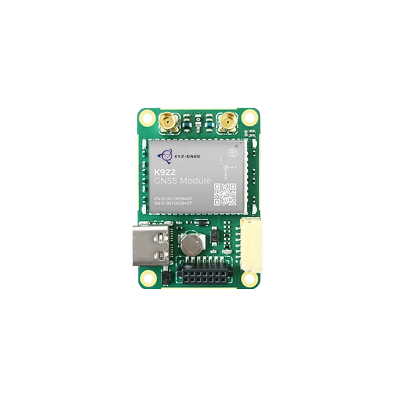
Comprehensive technical analysis of high-precision positioning solutions for modern autonomous systems and industrial automation.
The Evolution of High-Precision Positioning
In the rapidly advancing world of autonomous navigation and industrial automation, the demand for precision has moved from meters to centimeters. At the heart of this revolution lies the RTK GNSS module, a sophisticated hardware component that leverages Real-Time Kinematic (RTK) technology to provide unprecedented accuracy. Traditional Global Navigation Satellite Systems (GNSS) are often limited by atmospheric delays and orbital errors, leading to positioning discrepancies that are unacceptable for modern robotics or precision agriculture. The integration of an RTK GNSS module corrects these errors in real-time by processing the phase of the satellite signal's carrier wave, rather than just the information content of the signal.
Understanding the fundamental mechanics of an RTK GNSS module is essential for engineers and project managers looking to implement high-precision solutions. These modules act as the primary interface between the physical world and digital navigation systems. By utilizing both a base station and a rover, the RTK GNSS module can eliminate common-mode errors, delivering a relative positioning accuracy that is often within 1-2 centimeters. This level of precision is not merely a luxury but a requirement for applications such as unmanned aerial vehicles (UAVs), autonomous ground vehicles (AGVs), and sophisticated surveying equipment.
As we look deeper into the architecture of a high-performance RTK GNSS module, we see a convergence of multi-band and multi-constellation support. This means the module is capable of tracking signals from GPS, GLONASS, Galileo, and BeiDou simultaneously across multiple frequencies (L1, L2, and L5). This redundancy ensures that even in challenging environments, such as urban canyons or under heavy foliage, the positioning data remains robust and reliable. The following sections will explore the specific features, integration strategies, and industry-specific benefits of utilizing a professional RTK GNSS module in your next technological endeavor.
Core Mechanics of an RTK GNSS module
The operational principle of an RTK GNSS module is based on the measurement of the carrier phase of the satellite signals. Unlike standard GPS receivers that calculate distance based on the time it takes for a coded signal to travel from the satellite to the receiver, an RTK GNSS module measures the number of cycles of the carrier wave between the satellite and the antenna. Because the wavelength of the carrier signal is much shorter than the wavelength of the modulation code, this method allows for a much higher resolution of measurement. However, this process introduces the "integer ambiguity" problem—determining the exact number of full cycles between the satellite and the receiver—which the module’s internal algorithms must solve within seconds.
To function effectively, an RTK GNSS module typically operates in a "Rover" and "Base Station" configuration. The base station is placed at a known, fixed location where it observes the same satellites as the rover. It calculates the difference between its known position and its satellite-derived position and broadcasts these corrections to the rover via a data link, often using the RTCM (Radio Technical Commission for Maritime Services) protocol. The RTK GNSS module on the rover then applies these corrections to its own observations. This real-time exchange allows the rover to negate ionospheric and tropospheric delays, which are the primary sources of error in standard GNSS positioning.
Modern modules have evolved to support "Network RTK" or VRS (Virtual Reference Station) capabilities. In this scenario, the RTK GNSS module does not require a physical base station nearby. Instead, it connects to a network of permanent reference stations via cellular internet. The network calculates a localized correction model based on the rover’s approximate position and sends it back. This flexibility has significantly lowered the barrier to entry for businesses requiring high-precision data without the logistical burden of managing their own base station hardware. Furthermore, the internal processing power of the RTK GNSS module has increased, allowing for faster "Time to First Fix" (TTFF) and improved heading accuracy when using dual-antenna configurations.
Key Features of a High-Performance RTK GNSS module
When selecting an RTK GNSS module for industrial use, several technical specifications must be evaluated. The first is multi-constellation support. A module that can access all four major global constellations (GPS, BDS, GLONASS, GALILEO) provides significantly better availability. If a signal from one constellation is blocked by a building, the RTK GNSS module can switch to another without losing its centimeter-level fix. This is particularly crucial in precision agriculture, where machinery must operate consistently across vast and sometimes obstructed landscapes.
Another vital feature is multi-band capability. High-end modules typically support L1/L2 or L1/L2/L5 bands. By comparing signals on different frequencies, the RTK GNSS module can internally cancel out the dispersive effects of the ionosphere. This results in a faster "Fixed" solution and greater stability over long distances from the base station (long baselines). Without multi-band support, an RTK system is much more susceptible to atmospheric interference, which can cause the positioning to drift or revert to "Float" mode, where accuracy drops to the decimeter level.
- Raw Data Output: Ability to output RAW observations for post-processing (PPK) applications.
- High Update Rate: Position update rates of 10Hz to 20Hz are essential for high-speed UAVs and autonomous cars.
- Low Power Consumption: Crucial for battery-operated IoT devices and handheld surveying tools.
- Interference Mitigation: Advanced filtering techniques to protect against spoofing and jamming.
Lastly, the physical interface and form factor of the RTK GNSS module play a role in integration. Most industrial modules utilize standard UART, USB, or I2C interfaces, making them compatible with microcontrollers and single-board computers like Raspberry Pi or Jetson Nano. High-reliability modules are often designed with surface-mount technology (SMT) for automated assembly or as plug-and-play boards for rapid prototyping. These hardware features, combined with robust firmware, define the overall performance of the RTK GNSS module in real-world scenarios.
Industrial Integration of RTK GNSS module Technology
The integration of an RTK GNSS module into industrial workflows has transformed traditional sectors. In precision agriculture, for example, the module is the core component that enables autonomous tractors to follow paths with centimeter-level repeatability. This precision reduces overlaps and gaps in seeding and spraying, leading to significant savings in fuel, fertilizer, and time. By utilizing an RTK GNSS module, farmers can optimize their yields and implement "controlled traffic farming" to minimize soil compaction, a task that is impossible with standard GPS receivers.
In the realm of Unmanned Aerial Vehicles (UAVs), the RTK GNSS module provides more than just positioning; it offers high-precision altitude and heading data. For photogrammetry and LIDAR mapping, knowing the exact location of the drone at the moment a sensor is triggered eliminates the need for numerous Ground Control Points (GCPs). This streamlines the surveying workflow and allows for the creation of highly accurate 3D models and orthomosaics. The ability of the RTK GNSS module to maintain a "fixed" status during flight ensures that the data collected is geographically consistent, even over rugged terrain.
Robotics and autonomous logistics also rely heavily on RTK GNSS module capabilities. Delivery robots navigating sidewalk environments or port automation vehicles moving shipping containers require precise localization to avoid obstacles and dock accurately. Integrating an RTK GNSS module with other sensors like IMUs (Inertial Measurement Units) and wheel encoders creates a "sensor fusion" environment. This allows the system to maintain accurate positioning even if the satellite signal is briefly lost under a bridge or between tall containers. The synergy between high-precision satellite data and local sensor feedback is the cornerstone of modern autonomous navigation.
Strategic Implementation of an RTK GNSS module
Successfully implementing an RTK GNSS module requires more than just high-quality hardware; it requires strategic planning regarding antenna placement and data link reliability. The antenna is the "eye" of the RTK GNSS module. It must have a clear view of the sky and be placed on a ground plane to minimize multipath interference (reflections from nearby surfaces). For industrial applications, using a high-gain, multi-frequency helix or survey-grade antenna is often necessary to maximize the module’s performance. Poor antenna quality is the most common reason for an RTK GNSS module failing to achieve a "Fixed" solution.
Furthermore, the communication link between the base station (or network) and the rover's RTK GNSS module must be robust. In remote agricultural areas, long-range (LoRa) radio links are often used to transmit RTCM corrections. In urban or industrial settings, cellular (4G/5G) connectivity via NTRIP (Networked Transport of RTCM via Internet Protocol) is more common. If the correction data is delayed or lost, the RTK GNSS module will eventually lose its centimeter-level accuracy. Developers must implement fail-safe mechanisms to handle these interruptions, such as dead reckoning or fallback to high-precision GNSS modes.
Another strategic consideration is the use of dual-frequency heading modules. Some advanced RTK GNSS module units can process signals from two separate antennas simultaneously. This allows the system to determine the precise orientation (heading) of a vehicle even when it is stationary. This is a game-changer for applications like crane positioning, marine navigation, and autonomous mining equipment, where knowing which way the machine is facing is as important as knowing where it is. By selecting the right module architecture, businesses can future-proof their positioning solutions against evolving industrial demands.
Precision Solutions by Yonghao
At Yonghao, we specialize in providing world-class high-precision positioning components designed for the most demanding industrial environments. Our extensive portfolio includes the latest RTK GNSS module technology, meticulously engineered to deliver centimeter-level accuracy for UAVs, robotic systems, and precision agriculture. We understand that in the world of autonomous navigation, reliability is paramount, which is why our modules are tested to withstand extreme conditions while maintaining superior signal tracking capabilities.
Our flagship products, such as the YHRTK-982 and the ZED-F9P series, offer multi-band, multi-constellation support to ensure your projects never lose their fix. Whether you are building a fleet of autonomous delivery drones or a sophisticated surveying tool, our RTK GNSS module solutions provide the technical edge needed for success. Beyond modules, we also offer comprehensive anti-jamming solutions and high-gain antennas to create a complete, robust positioning ecosystem.
Yonghao is committed to innovation and customer success. We provide deep technical support and customization services to help you integrate our RTK GNSS module into your specific hardware architecture. Our expertise in satellite navigation allows us to bridge the gap between complex satellite physics and practical, real-world application, ensuring that our clients achieve the precision they require with maximum efficiency. Partner with Yonghao to experience the pinnacle of GNSS technology and drive your industrial automation to the next level.
Frequently Asked Questions
Q1: What is the main benefit of using an RTK GNSS module over standard GPS?
The primary benefit of an RTK GNSS module is the achievement of centimeter-level accuracy (typically 1-2 cm). Standard GPS modules usually provide accuracy in the range of 1.5 to 5 meters. This dramatic improvement is achieved through real-time carrier-phase measurements and error corrections from a base station or network, which eliminates atmospheric and satellite clock errors.
Q2: Can an RTK GNSS module work without a local base station?
Yes, an RTK GNSS module can function without a private local base station by utilizing Network RTK or NTRIP services. These services provide correction data over the internet from a network of pre-existing reference stations. This allows the user to achieve high-precision positioning as long as they have a cellular or internet connection to receive the correction streams.
Q3: How long does it take for an RTK GNSS module to reach a "Fixed" solution?
The time required for an RTK GNSS module to achieve a "Fixed" status, known as Time to First Fix (TTFF), typically ranges from 10 to 60 seconds under optimal sky conditions. Multi-band modules (L1/L2/L5) generally achieve a fix much faster than single-band modules because they can resolve carrier-phase ambiguities more efficiently by comparing different signal frequencies.
Q4: Does weather affect the accuracy of an RTK GNSS module?
While an RTK GNSS module is highly resilient, extreme atmospheric conditions like solar flares or severe ionospheric disturbances can occasionally impact the stability of the fix. However, typical weather like rain, snow, or fog does not significantly affect the satellite signals. The module's ability to use multiple constellations and frequencies further helps maintain accuracy during varying atmospheric conditions.
Q5: What hardware interfaces are commonly found on an RTK GNSS module?
Most industrial RTK GNSS module units feature standard communication interfaces including UART (Serial), USB, and sometimes I2C or CAN bus. These interfaces allow the module to output positioning data in NMEA format and receive RTCM corrections from external radios or internet-connected microcontrollers, making them highly versatile for integration into various electronics.
Conclusion: Powering the Future with Precision
The RTK GNSS module has become the indispensable bedrock of modern high-precision applications. By providing centimeter-level accuracy, multi-constellation reliability, and seamless industrial integration, these modules enable the next generation of autonomous and automated technologies. As industries continue to demand higher efficiency and safety, the role of the RTK GNSS module will only grow in importance.
Ready to elevate your positioning accuracy?
Contact Our Engineering Team Today